Notes
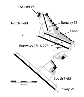 North Field
Oakland airport is actually two airports in one: North Field, which generally focuses on general aviation (GA), business aviation (Learjets, etc.), and air freight; and South Field, which focuses on the commercial airline side of things. The two fields have separate control towers and ATC frequencies, etc.
In the diagram at left (courtesy of the Federal Aviation Administration (the FAA), North Field is the series of three runways (in dark black) at the top; South Field is the single runway and main airline terminal in the bottom half. The two fields are intimately connected, and it's theoretically possible for GA to use South Field and airlines to use North Field, but that usually only happens when runway maintenance or something similar is happening, and usually only then late at night.
Runway 33 is the near-vertical black strip towards the top of the diagram; runways 27L and 27R are the two parallel angled black lines a bit further down the diagram (when there's more than one runway with the same heading, they're given right / left (R/L) designations, e.g. "runway 27 left"). Runway 29 (for the big boys) is the large angled black line at the bottom of the diagram. Runway 29 is big enough to take 747's and DC-10's (which is just as well, since Oakland is one of United's 747 maintenance centers, and UPS flies 747 freighters in and out of Oakland on a daily basis...).
And if you're wondering where Oakland itself is, it's just across San Francisco Bay from San Francisco in the lovely Bay Area deep in Northern California. Oakland's supposedly the there that isn't, if you catch my Steinian drift....
"The Old T's"
Where the club's planes are parked. It's the small cluster of buildings in black right at the top left hand corner of the Oakland diagram above. And yes, there's also a "New T's", a few hundred metres across runway 15 / 33 from the Old T's. The name comes from the T-shaped tie-down markings painted onto the apron. Or at least that's what I've been told....
N739UL
All US-registered planes have a registration or license number beginning with "N", followed by one or more digits and letters, e.g. N739UL or N4312R. Under normal circumstances in the US you don't use the initial "N" when referring to the plane's number, and it's common to refer to the plane (with ATC, etc.) by just the last three digits and letters (and often the aircraft type), e.g. "Cessna 9UL" or "1-2-R".
Letters are spelled out using the international phonetic alphabet, so the above is always actually said as "Cessna niner-uniform-lima" or "one-two-romeo".
PAO
Airports are identified in the US formally by their three or four letter identifiers; e.g. Palo Alto is "PAO". These three letter codes are used almost universally in both formal and informal conversations, business, etc. , and keep cropping up in the diary.
Some common abbreviations for Bay Area and other Northern California airports, often used in this diary:
- PAO -- Palo Alto
- OAK -- Oakland International
- SFO -- San Francisco International
- LVK -- Livermore Muni airport
- APC -- Napa County airport
- SQL -- San Carlos
- CCR -- Concord Buchannan field
- HWD -- Hayward (just south of Oakland)
- SJC -- San Jose International
- RHV -- Reid Hillview Airport, San Jose
- STS -- Sonoma County Airport, Santa Rosa (Wine Country)
- C83 -- Byron (West Central Valley)
- CIC -- Chico, Sacramento Valley
- SMF -- Sacramento International
- RBL -- Red Bluff (near Redding, Sacto Valley)
- VCB -- Vacaville / Nut Tree, Solano County
- OAK -- Oakland International
Note: to conform to international standard, most US codes should have the letter "K" prepended to them, e.g. SFO is really KSFO according to international usage. Americans tend to ignore this, but it's becoming more common in official usage.
"10 knot wind from 280"
Aviation airport weather reports typically give ground wind directions in magnetic headings, wind speeds in knots (nautical miles per hour). Typical weather reports for pilots will say something like "wind 240 at 15 gusting 20", meaning the wind is coming from 240 degrees (a little to the south of west, i.e. roughly west-south-west) at a measured speed of 15 knots, gusting to a measured maximum of 20 knots.
Winds at Oakland during the nine-month non-winter are nearly always something like "240 at 10", i.e. from the west(ish), and fairly steady.
The Club
The Alameda Aero Club, a small non-profit flying club based at the Old T's in Oakland. It's the only way I can afford to fly.... Founded some time ago by ex-Naval aviators at NAS Alameda. My membership card still claims we're based at NAS Alameda, even though NAS Alameda's been closed for nearly a decade....
Pre-Flight
The act of walking around an airplane prior to flying it, inspecting everything essential to flying: fuel levels and quality, propeller and control surfaces, tire pressures, oil levels, etc. This is an absolutely essential step to any flight.
ATIS
Automated Terminal Information System. Basically a tape loop broadcast on its own frequency at busier airports, with information about the weather at the airport, what runways are in use, special notices, etc. You listen to this before starting a flight, and when approaching an airport. The newer versions use a computerised voice which sounds very odd, at least to my ears. For a taste of ATIS, call +1-510-635-5850 (a toll call if you're not in the area...) and you'll hear the automated information tape loop for OAK (Oakland). It's full of jargon; you're not expected to understand it if you're not a pilot or student.
ATC
Air Traffic Control. Usually used here as shorthand for any of the main ATC functions: ground control, clearance delivery, tower, approach and departure, center, etc. Basically, they line up something like this (greatly simplified):
- Ground control: responsible for controlling planes taxiing on the ground, getting them to and from runways, etc.
- Clerance delivery: in bigger airports, responsible for issuing clearances to planes wanting to take off into certain types of controlled airspace.
- Tower: responsible for safely sequencing takeoffs and landings.
- Approach: basically responsible for getting planes to the airport before handing them off to the tower.
- Departure: approach in reverse. Gets you after takeoff when the tower no longer wants you.
- Center: responsible for controlling planes during cruise or away from the main airport approach / departure areas.
- Clerance delivery: in bigger airports, responsible for issuing clearances to planes wanting to take off into certain types of controlled airspace.
Some or all -- or none -- of these functions may exist at particular airports. At Oakland, for example, which is a busy Class C airport under a busy Class B airspace, ground and clearance delivery are combined for North Field, but everything else exists and you must be cleared by and / or acknowledged by the relevant ATC function. This can be really intimidating and complex to newcomers, but smaller GA planes on visual flight rules (VFR) typically don't have to interact with every ATC level all the time.
Runway 29
Runways are given names or identifiers corresponding to their magnetic heading divided by ten and rounded; runway 29 (the big runway at Oakland) has a heading of (roughly) 290, (a little north of west) while runway 33 has a heading of around 330 (a little west of magnetic north).
But runways go in two directions, you say... yes, runway 33 is also runway 15. Or rather, runway 15 is the same strip as runway 33, but seen from the other direction. Ditto for 29 / 11 and 27 / 9.
If there's more than one runway with the same heading, they're typically given "left" and "right" designations, e.g. OAK's 27L and 27R (9R and 9L respectively if seen from the other end).
The Numbers
Phrases like "above the numbers" or "on the numbers" in this context refer to the big painted numbers on every runway. In this case, we had to fly directly above the big painted "29" at the eastern end of runway 29 at or above 1,000'. Landing "on the numbers" means just that: you touch down on or a little beyond the painted numbers on the runway (doing this gives you maximum runway length for stopping). Hopefully the numbers on the correct runway....
The numbers on runways are designed to be visible from a fair distance and altitude.
Class B Airspace
US airspace is organised into a set of classes (A to G, but no "F" for some reason). The rules for defining airspaces and what you can do in them are complex, but basically:
- Class A airspace is tightly-controlled, instrument flying only, and above 18,000 feet. This tends to be where the jets are while cruising....
- Class B airspace surrounds the biggest airports (like SFO). Class B airspace is tightly controlled, and usually very busy. Student pilots can't fly in Class B airspace without their instructor's explicit written endorsement [which I now have... HR].
- Class C airspace surrounds busy airports like Oakland or San Jose. It's not quite as tightly controlled as Class B, but still has radar, full ATC services, etc. They let people like me fly in Class C.
- Class D airspace surrounds smaller airports (like PAO or LVK) with a control tower, but not (usually) radar. Often very busy. Often scarier than class B or C because of the lack of radar....
- Class E airspace is all controlled airspace that isn't one of the above. Most of the US airspace below 18,000 feet and not one of class A, B, C, or D is class E.
- Class G airspace is uncontrolled airspace, typically just the lowest altitudes away from airports. There's not a lot of it in the Bay Area....
- Class B airspace surrounds the biggest airports (like SFO). Class B airspace is tightly controlled, and usually very busy. Student pilots can't fly in Class B airspace without their instructor's explicit written endorsement [which I now have... HR].
The various navigation charts show the airspaces in standard ways; click on the small image below in the "Sectionals and Terminals" section below to see an example of the mixture of classes A, B, C, D, and E within a few miles of OAK. No, it probably won't make much sense, but it's interesting....
Runup
Before taking off, small planes do a runup. This basically means running the engine at a fairly high power setting for a few moments to check that nothing's obviously broken, that the oil pressure is OK, that the magnetos and carburettor heat seem to be working, etc.
VFR
Visual Flying Rules. Basically the rules smaller planes fly under when conditions are good enough to be able to fly visually, i.e. without needing the various instruments to navigate and keep flying level, etc. The opposite of IFR, which means instrument flying rules. To fly IFR, you must be IFR-certified and be flying an IFR-capable plane. IFR allows you to fly through clouds, etc., in ways absolutely prohibted by VFR.
"The Sunken Ship"
An actual (small) sunken ship in the Bay, easily visible from the air, and consequently a landmark used for reporting position to ATC when over the Bay. Not easily visible from land, and poorly marked on the various charts, but a bit of local knowledge goes a long way here....
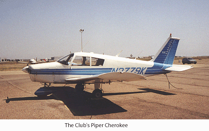 "Cherokee"
The Piper Cherokee, a small low-wing GA plane. GA people have endless religious arguments about whether high-wing planes (like the Cessna 172) are better than low-wing planes (like the Cherokee), but they both fly....
"Right traffic for runway 30"
Planes don't typically just turn up at an airport and land however they like -- GA planes under VFR usually join and fly the pattern to a particular runway. This pattern is usually rectangular, with crosswind, downwind, base, and final components. A right pattern (or right traffic) means the pattern is flown with right turns, i.e. clockwise when looked at from above. The more common left pattern is the reverse. Pattern directions and altitude depend heavily on local factors such as other runway alignments, noise abatement areas, and things like local terrain.
E6B
The E6B is an odd, purely-mechanical calculator dating from earlier this century, still used by many GA pilots to calculate things like fuel consumption, crosswind components, etc. Basically a glorified circular slide rule, for those of you who remember what a slide rule is.
Jeppesen Text
The name "Jeppesen" keeps cropping up in US aviation circles: Jeppesen (Jepp) is a widely-known company that makes and sells charts, books, software, etc. for pilots. The text mentioned here is their Private Pilot's license text. It contains the vast amount of stuff you have to know to pass your written test.
IMC
Instrument Meteorological Conditions. Basically it means the weather's too poor to fly without instruments. The opposite of VMC, visual meteorological conditions. See also VFR. You have to have an instrument rating to fly legally in IMC.
Sectionals and Terminals
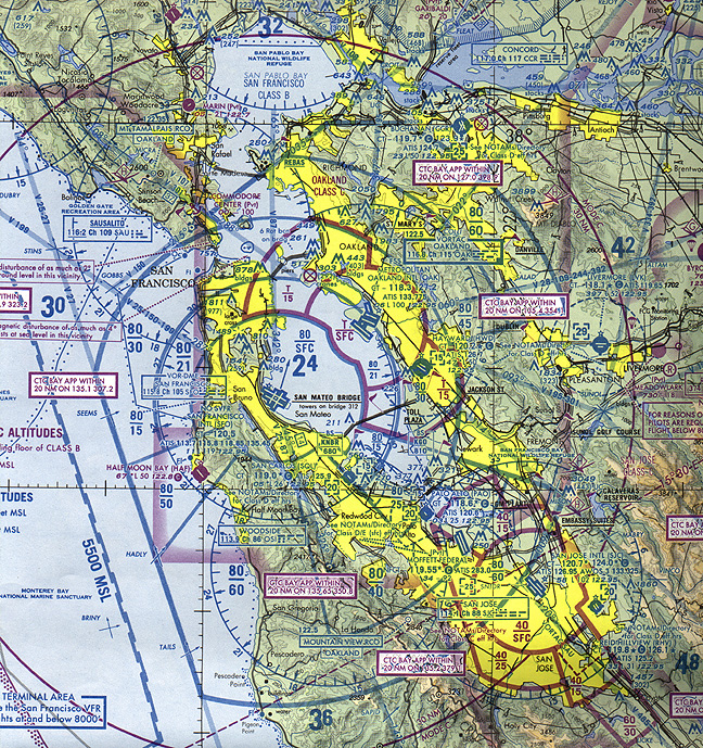 Sectional and terminal charts. Sectionals cover a large area at a scale of 1:500,000 (e.g. the San Francisco sectional covers an area from about Big Sur in the south to Red Bluff in the north, and well into Nevada on the east). 37 sectionals cover all of the lower 48 states; they're used mostly for VFR navigation away from the most congested areas. Terminal charts cover a specific class B airspace at a scale of 1:250,000. These are basically for VFR navigation in the heavily congested terminal areas.
The example at left is a small part of the San Francisco sectional covering most of the Bay Area.
turn coordination ball
An instrument that indicates whether the plane is turning, and, if so, which way, and whether the turn is coordinated. A coordinated turn is a turn which has no skidding or slipping components, i.e. where the bank angle is correct for the turn (think of cars on banked roads for an analogy -- they skid if the bank angle (the road's camber) is too little, slip if it's too great).
MCA
Minimum Controllable Airspeed. Basically MCA maneuvers are exercises in controlling the aircraft just above stall speed. It's quite difficult the first few times you do it, and you're always on the edge of stalling the plane. A specialised form of the more general slow-speed flying.
Stalls
(Very much simplified and dramatized...), stalls are when the plane's wings stop generating enough lift and the plane starts falling out of the sky, usually rather quickly.... The drama involved when stalling depends on the type of plane (our little Cessna is relatively benign), the altitude at which they happen, and whether or not the pilot's aware of the impending stall. You absolutely have to learn how to recover from a stall -- and, just as importantly, to recognise an impending stall and stop it before it develops into a real stall -- to be able to fly properly. Stalls on final are real killers....
The Temple
The Mormon Temple nestled in the Oakland hills about 5 nm from Oakland airport. Another Bay Area ATC reporting landmark, also inexplicably difficult to find on charts. Again, local knowledge goes a long way when Bay Approach tells you to "maintain 2,500 over the temple".... At least it's easy to see, looking like a rather ostentatious mini-Disneyland or theme park (for years I lived here and thought that that was exactly what it was. Oh well. Nothing like insulting a whole religion. Sorry.)
VOR
VHF Omnidirectional Range. Basically a radio beacon that can accurately tell you what (absolute) direction you are from the transmitter. Forms the backbone of the US instrument navigation system (with a bunch of other things like DME -- distance measuring equipment -- and, more and more nowdays, GPS). Also very useful for VFR navigation.
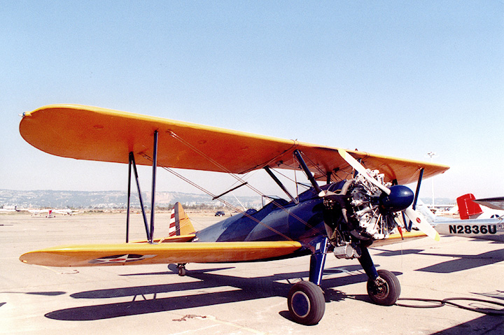
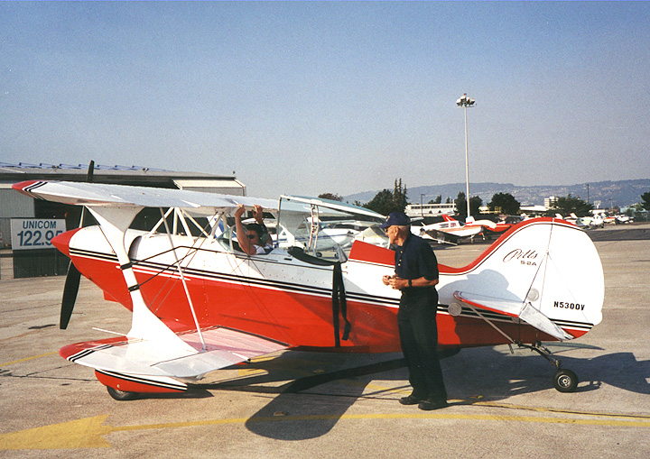
Stearman or Pitts
Two types of aerobatic planes, both biplanes. There's a Stearman or two based at Oakland; locals know them as the planes that tow advertising banners around the Bay Area, usually over the various sports arenas. Beautiful aircraft, with open cockpits, a real joystick control system, a radial engine, etc. Lou Fields has a beautiful Pitts S-2A at the Old T's as well.
Vno
Highest normal operation speed. In 12R, about 145 MPH. You shouldn 't fly the plane any faster than this except in very smooth conditions, and without any maneuvering.
PTS
Practical Test Standards. The FAA spells out the standards you have to meet to pass your practical test in the private pilot PTS. Typically things like "lose or gain no more than 100 feet during power-off stall recovery", etc.
The 5 F's
The procedure to follow if your engine fails: fly (the plane at best glide speed, Vg), find (somewhere to land), fix (try to fix what's wrong if you can), frequency (tell ATC or other aircraft that you've got an emergency, etc.), and flee (basically get ready to crash).
Slip
Slipping is a maneuver that lets you lose a lot of altitude very quickly without gaining airspeed, or, alternatively, to approach a runway in a stiff crosswind without crabbing. Very useful maneuvers.
JESS99
Java Enterprise Solutions Something-or-other. Typical nerd junket where I get to go to Paris (in Spring!) for a week at my company's expense. Recompense for being our company's tame Java nerd. Oh, and you should see our Paris office up there on the 14th floor of Le Grande Arche, La Defense....
Touch and Goes
Practice maneuver where you land the plane and then, without stopping, take off again. The name is pretty descriptive....
FAR/AIM
Federal Aviation Regulation / Aeronautical Information Manual. The FARs spell out in great detail the regulations you need to know and observe while flying (and get tested on for the written exam); the AIM is a less formal overview of the sort of things (like runway signs, airspace conditions, etc.) that you need to know to actually fly. They're both government documents, but usually printed and distributed in book form by companies like ASA.
Squawk
When ATC asks you to squawk (say) "0120", they're asking you to set your aircraft's transponder code to 0120. The transponder sends a signal back whenever it senses an incoming radar pulse; this return signal identifies the radar blip as your plane, and also typically encodes your plane's altitude so it can be displayed in the radar screen.
Johnnie Johnson
A British RAF fighter ace during the second war. Perhaps not as famous as Douglas Bader, but my grandfather knew him, and I grew up with stories and books about him and the other RAF pilots of that time. I met several of them as a kid; one in particular, a Spitfire pilot who was blinded by a post-crash fire after being shot down and unable to get out of his plane, stayed in my mind for years (he was still active and graceful in his sixties). These guys were real heroes to me as a young kid.... My grandfather also knew Bader a little, and once told me he couldn't get on with him at all. Not an uncommon reaction, apparently.
I re-read Johnson's "Wing Leader" out of interest -- it was in a large pile of my old childhood books my brother had sent over from Australia a few months ago. I hadn't looked at it since I was maybe 12. A good read, with an absolutely classic of-its-era jacket photo of Johnson suavely smoking a cigarette in RAF uniform. What surprised me was just how much of the actual flying and mechanical details were familiar to me -- slips, variable-pitch props, the pattern, etc. Fifty-something years later....
DUATS
An automated version of some of the FAA's FSS (Flight Service Station) functions. Allows you to access weather briefings, file flight plans, etc., online. There's a web version which is really useful. You need to be a registered pilot or student to use DUATS, though.
FSS
Flight Service Station. The US FAA operates a bunch of these offices (there's one at Oakland); their main aim is to provide weather briefings and flight planning help. You rarely see FSS briefers in person any more: they're usually accessed through radio (either on the ground or in the air), or via an omni-present 1-800 number with voicemail.
Citabria
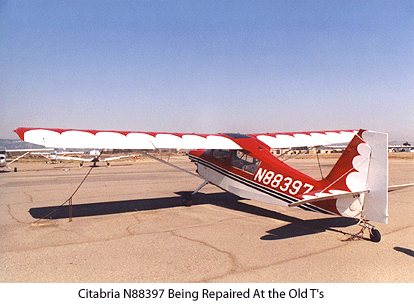 Another small aerobatics plane, this time a high-winged monoplane with a standard non-radial engine. Fabric-covered wings and fuselage, two seater (in-line), stick controlled. Nice looking aircraft; there's a bunch of them based at OAK, with a nice red and white one (N88397) just outside Lou Fields's hangar a hundred metres or so from the club.
The name sounds vaguely Spanish or Italian (very Latin), but try looking at the name backwards....
REBAS
A particular intersection of two specified Bay Area VOR radials (in this case, Scaggs Island (SGD) and San Francisco (SFO)). REBAS is a convenient fix over Richmond (north of Oakland) that's familiar to many VFR pilots as marking the end of one of the SFO class B airspace sectors in that area. It's marked on the (VFR) SF terminal chart, unlike most intersections.
Intersections and fixes are usually used for IFR navigation (they're waypoints for the Victor Airways system, which is the highway-in-the-sky IFR route system between VORs, as well as for approach and departure procedures). There are literally thousands of these fixes defined. They get five letter names like "HAYZE" (over the Oakland Hills coming into Hayward, pronounced "hazy"), "PANIC" (Minnesota), "FUBAR" (Arizona), "CATLE" and "HOWDY" (both in Texas, natch), or the sequence of fixes in New Hampshire: "ITAWT ITAWA PUDYE TTATT IDEED" (I'm not making this up -- check with Airnav's fixes page if you don't believe me...).
Intersection names are the only extant evidence that the FAA has any sense of humour at all.
CTAF
Common Traffic Advisory Frequency. When you approach and / or take off or land at an uncontrolled field (i.e. one without a working control tower) you are supposed to announce your intentions at every stage in the approach and pattern on this frequency, and listen for other traffic.
Since the majority of small airports in this country are unctontrolled (or at least not tower-controlled 24 hours a day), learning how to announce on, and listen to, CTAF is an essential skill. It's made harder by the fact that -- around here, at least -- CTAF frequencies are shared between many airports close together, meaning the frequency is often busy and confusing. On a good day in the Sacramento Delta, at (say) Rio Vista, it's possible to be sharing CTAF with planes landing at Placerville, 100km away in the Sierra foothills, among other airports. This gets confusing....
The story about the Cardinal over Petaluma is a classic (but mild and relatively benign) case of what happens when pilots either forget to announce on CTAF, or just don't bother.
MVFR
Marginal VFR. Means the weather is still, strictly speaking, VMC, i.e. it's legal to fly VFR, but VFR is not recommended. Usually means the weather is close to but not at the legal VFR minima for the airspace(s) concerned.
Blue Book
The "Blue Book" is the, erm, blue book published by Optima Publications that lists all California (and a few Nevada) airports with airport diagrams, notes on VFR approach and departure procedures, FBO phone numbers, local hotel information, etc. Indispensible if you're going somewhere unfamiliar. Officially titled the "Pilots Guide to California Airports".
Basically a readable version of the official FAA Airport and Facilities Directory (A/FD).
FBO
"Fixed Base Operator". Officialspeakjargon for on-airport service provider. The GA and bizzjet equivalent of a service station, where you can get fuel, repairs, rent planes, buy supplies, etc., depending on the establishment. Kaiser at OAK is a typical big FBO, catering to everything from corporate 727's and Learjets to individually-owned Cessna 172's; more typical FBO's inhabit places like Red Bluff and Chico and cater to the GA crowd only.
Flight Following
VFR aircraft can ask ATC for flight following while flying through controlled airspace. What this basically means is that -- if ATC has enough bandwidth to provide it -- participating aircraft are actively tracked on radar and issued traffic advisories if traffic conflicts occur or could occur. Flight following is not full tracking or active control by ATC -- if you veer off course no one in ATC will comment unless it's towards something grossly unsafe (like a high peak in the immediate vicinity) or ATC suspects something's wrong. It's basically just about keeping an eye out for conflicting traffic. Note: ATC can't always provide flight following -- sometimes they're just too busy, or (this happens frequently with small planes in the Sierra or Coast Ranges) your aircraft is too low to be visible to enroute radar.
Flight following is very advisable for obvious reasons, but the best reasons of all is that there's someone in ATC who knows where you and who you are are if things go wrong. This is a Good Thing, and, if you've got it, more useful than a flight plan (in my opinion. You really want both, of course...).
OAT
Outside Air Temperature. It's useful to know the OAT because it affects things like airspeed and altitude due to its effects on air density. On 12R and its ilk, the OAT guage is on the right hand air vent where the leading edge of the wing joins the cockpit.
Unicom
The Unicom frequency is, according to the AIM, "a non-government communication facility which may provide airport information at certain airports". It's typically the frequency you call the local FBO on for fuel, etc. Often the same frequency as CTAF.
Segmented Circle
A segmented circle is used at uncontrolled airports to show wind direction and pattern direction for each runway at that airport. A bit hard to describe, segmented circles look from the air like some sort of ancient 40 foot radius stone circle with a windsock rising out of the centre, and little arms coming from the appropriate places on the circle to show pattern direction.
PIREP
Pilot Report. ATC encourages pilots to report weather observations to local ATC weather centres so that the weather people have a better idea of what's really happening up there in the sky.
ALSF-2
"Approach Light System with Sequenced Flashing Lights in ILS Cat-II configuration. The ALSF-2 may operate as an SSALR when weather conditions permit" (AIM). Doesn't begin to describe the trippy riot of colour and movement in real life....
ILS
Instrument Landing System. The ILS is what guides you down onto the runway from a few tens of miles out during low-visibility (IMC) approaches. Usually has a localiser (horizontal) component and a glideslope (vertical) component.
vectors
ATC-assigned headings, e.g. "12R make a left turn to 180", meaning turn left until you're heading 180 degrees magnetic (south). Often assigned for traffic collision avoidance or to get you to the starting point for an approach or enroute airway.
middle marker
A radio marker beacon that's usually placed at the point along the ILS glideslope where the glideslope reaches the category I ILS decision height. Basically, if you can't see the runway by this point on a category I ILS approach, you have to abandon the approach and either try again or go elsewhere. Category I ILS approaches have the highest decision heights (Cat-III approaches have no decision heights: the plane is flown onto the runway entirely by instruments. Only the big boys with 747's and 777's, etc., with precision instruments and computer guidance get to do this). The middle marker makes a dot-dash beeping in the audio system if it's turned on when you're above it.
MALSF
"Medium Intensity Approach Light System with Sequenced Flashing Lights" (AIM). A sober version of ALSF-2 runway / approach lighting. Boring but safe.
diversion
The diversion is the procedure you're supposed to follow when you decide abruptly to change destinations, usually at the behest of the instructor or examiner (in real life, it's usually due to sudden mechanical or weather problems). You're not allowed to just point the plane in the new direction by looking out the window and using local knowledge about where the airport you're diverting to is -- you have to work out the exact new heading on the charts with plotter, pencil, etc., tell ATC what you're doing, and then do it safely and smoothly. Difficult to do perfectly while flying along at 120 MPH in a small unstable plane in crowded class B or C airspace.
checkride
The checkride is the practical part of the final private pilot certificate test. The test has two parts: the oral exams (desribed elsewhere), and the checkride. The checkride is basically a run through of all the airwork, landings, emergency procedures, etc., in real time with an FAA or designated examiner (DE). If you pass both the orals and the checkride, you have the license (modulo bureaucratic problems, etc.). The checkride is usually pretty grueling, with non-stop test piled on top of eachother, and with an examiner who typically has never seen you before and always expects the worst.
VFR on top
Basically just a way of using IFR to get above the clouds; when you're above the clouds you cancel IFR and proceed VFR. Very useful in places like the Bay Area where the fog and clouds cover the area until midday, but top out at about 2,500' or lower, and / or disappear within a few miles of the airport (e.g. over the Berkeley Hills). Going VFR on top relieves you of the often onerous task of staying IFR for long periods in a small plane without an autopilot.
DE
Designated examiner. A non-FAA instructor who the FAA has blessed with being able to conduct flying exams. An expensive but convenient alternative to getting a real FAA examiner.